Where to stand for the best view of Lake Louise
The famous view is free and flat: the paved shore in front of the Chateau, looking down the lake at the Victoria Glacier. Every other viewpoint is a climb, from the 45 minutes walk to Fairview Lookout to the four-to-five-hour day on the Big Beehive. Which one to pick, and which end of the day to pick it.
Updated Mountain Time.
Sunset time today
Sunset 7:57 pm today, sunrise 7:21 am
Computed for the lakeshore on Wednesday, September 16 with the standard NOAA solar routine, for a flat horizon. The lake sits in a mountain bowl, so the sun leaves the water before the printed sunset and reaches the glacier after the printed sunrise. The lake is normally open water and at its strongest colour, fed by glacial meltwater.
The view from the shore, and where on the shore
Stand on the paved area in front of the Chateau and look straight down the lake: that is the view on every postcard, and it is the one place here that needs no climb. The lake runs southwest from the hotel to the Victoria Glacier, so the glacier is at the far end of the frame and the water fills the rest.
| Lakeshore Trail, one way | 2.3 km |
|---|---|
| Climbing | minimal |
| Time, there and back | 1 hour |
| Cost of the view | free, after park entry and parking |
| Park entry, adult per day | $12.25 |
| Lakeshore parking, 15 May 2026 to 12 October 2026 | $42 a day |
| Lakeshore parking, rest of the year | free |
The crowd stands in the first two hundred metres, around the canoe docks and the boathouse. The trail data on this site says it plainly: the classic frame is taken from the paved area in front of the Chateau, not from the trail, and it works best in the first hour of light before the sun reaches the water. For a quieter version of the same view, walk fifteen minutes along the north shore and shoot back towards the hotel. The lake is in the frame and the crowd is not.
The Lakeshore Trail runs the length of the north shore, the only shore with a path on it, and the colour changes as you walk. From the Chateau the water reads pale turquoise; by the far end it is deeper and greener, because you are closer to the meltwater carrying the rock flour that makes the colour. You pass under Fairview Mountain on your left and look across to the Big Beehive on your right. At the head of the lake the valley opens onto the glacier itself, and the quiet is noticeable after the boathouse.
In winter the same spot works at a kinder hour. The lake is normally open water and at its strongest colour, fed by glacial meltwater. Parking is free outside the paid season, and the low light lasts most of the day. The winter page has what is open.
Fairview Lookout: the classic view from above
Fairview Lookout is the short climb: 1.2 kilometres one way with 100 metres of climbing, about 45 minutes there and back, ending at a wooden platform that looks back across the lake at the Chateau. It is the best short walk here for anyone who wants a view without a mountain day, and it is the viewpoint people mean when they ask for the lake and the hotel in one frame.
| Distance, one way | 1.2 kilometres |
|---|---|
| Climbing | 100 metres |
| Descent on the way | 65 metres |
| Time, there and back | 45 minutes |
| Trailhead | Lake Louise lakeshore, opposite end from the Lake Agnes sign |
The trailhead is at the opposite end of the lakeshore from the Lake Agnes sign, which is why it is quiet: the crowd turns right for the tea house and this trail goes left. It is a forest walk until the platform, so save it for after the light has spread rather than climbing it in the dark. The same trailhead serves Saddleback Pass, 3.6 km one way with 600 m of climbing, and beyond it Fairview Mountain, 5 km one way with 990 m of gain and 5 to 6 h return, whose summit looks down on the lake from far above. Neither is a viewpoint walk; both are days.

The Big Beehive: the view from more than 495 metres up
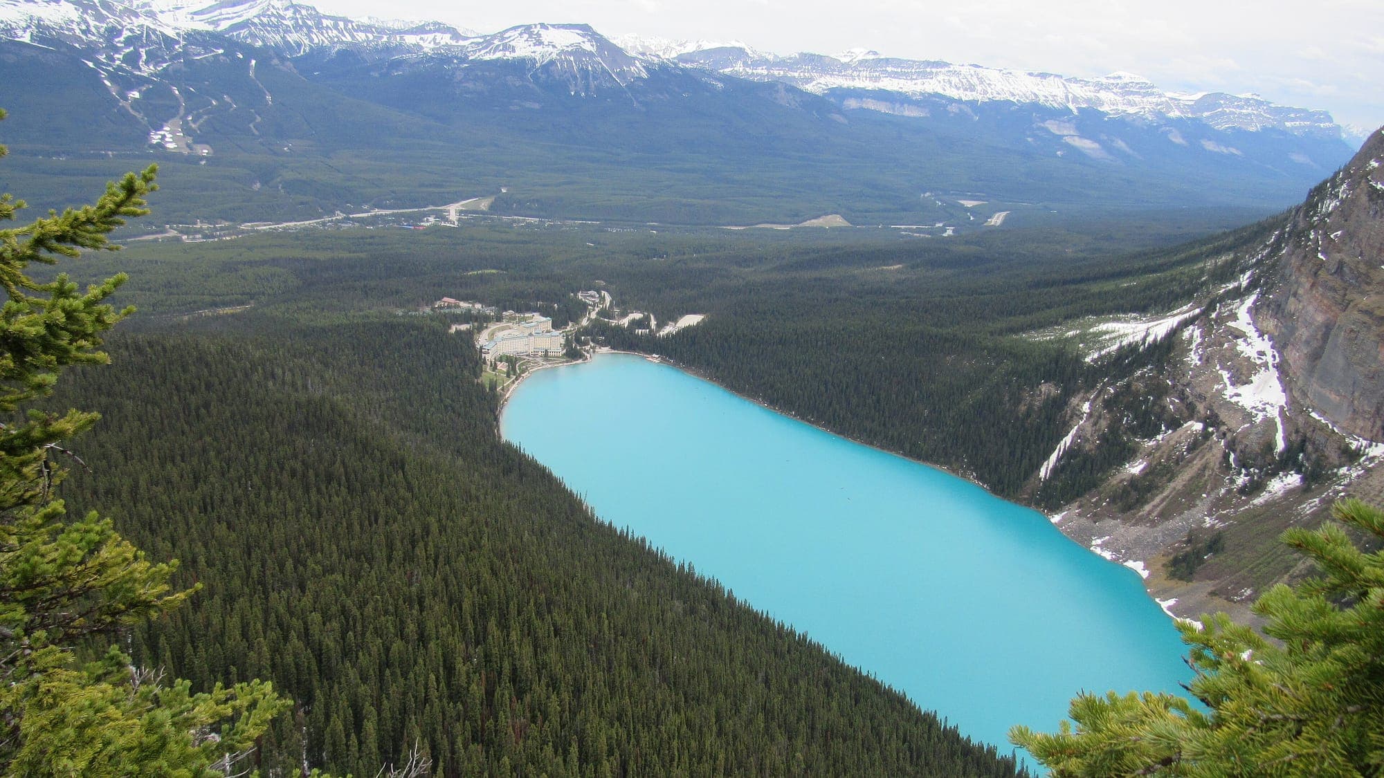
The Big Beehive has the definitive elevated view, straight down the full length of Lake Louise with the Chateau at the far end looking like a model. It costs a full morning: the climb to Lake Agnes first, then 1.5 km of switchbacks above the far end of that lake, and four to five hours in total from the shore.
| Lake Agnes, one way from the lakeshore | 3.9 km, 495 m climb |
|---|---|
| Big Beehive, from Lake Agnes | 1.5 km, 1 hour from Lake Agnes |
| Whole day, there and back | four to five hours |
| Difficulty | Hard |
| Little Beehive, from Lake Agnes | 0.9 km, 45 min |
The top is a broad rock dome with an open wooden shelter on it, and the lake sits directly below. Time it for the morning, when the light is behind you rather than in the lens. The switchbacks are the hardest sustained section of any trail at Lake Louise, a walk rather than a scramble, but with loose rock and a real drop beside the path. The Big Beehive page has the route and the loop down to the Plain of Six Glaciers.
The Little Beehive is the easier substitute, 0.9 km from Lake Agnes and about 45 min there and back. Looks out over the Bow Valley rather than down onto the lake. If the switchbacks look like more than you want after the tea house, it is the sensible choice, but it is not the lake view.

Lake Agnes and the Plain of Six Glaciers
The two tea house trails give two different views, and neither is the postcard: Lake Agnes is a hanging valley with a lake of its own, and the Plain of Six Glaciers puts you under the Victoria Glacier at the head of the valley, looking back down the lake towards the hotel.
| Lake Agnes | 3.9 km one way, 495 m climb, 2.5 to 3 hours return |
|---|---|
| Plain of Six Glaciers | 5.8 km one way, 595 m climb, 4 hours return |
On the Lake Agnes trail the view of Lake Louise comes on the way up, through gaps in the forest and from Mirror Lake under the Big Beehive; at the top you are looking at Lake Agnes, not Lake Louise. The Plain of Six Glaciers trail walks the full lakeshore first, then climbs the lateral moraine with the valley dropping away on one side. The last stretch to the tea house is the steepest, and the glacier is ahead of it the whole way. Parks Canada advises avoiding high elevation trails from November to June because of avalanche risk. The hikes page compares all of them.
Can you see the lake from the Fairmont without staying there?
Yes. The shore in front of the hotel is public lakeshore, and the view most people want is taken from the paved area there, not from inside the building. The Fairmont Chateau Lake Louise is a landmark luxury resort hotel of more than 500 rooms directly on the lakeshore, open year-round — the only hotel on the lake itself.
| Park entry, adult per day | $12.25 |
|---|---|
| Park entry, family or group per day | $24.50 |
| Free entry for everyone, Canada Strong Pass | 19 June to 7 September 2026 |
| Lakeshore lot, 15 May 2026 to 12 October 2026 | $42 a day |
| Park and Ride, with a shuttle booking | free |
| Parks Canada shuttle, adult | $12.75 |
| Hotel room rate | not published; the hotel quotes on booking |
What a room buys is the hour, not the view: a guest walks out of the lobby at dawn while everyone else has driven up in the dark for a space in the lot, which Parks Canada says fills by sunrise in summer. The parking page has the full picture and the shuttle page the way around it. The hotel listing has the phone number. This site has not verified a public-access policy for the building itself, so it does not state one; the shore needs none.
Sunrise or sunset at Lake Louise?
Sunrise, if the famous view is the point. From the shore you look southwest down the lake, and the sun comes up behind you over the ranges across the Bow Valley, so the glacier wall is lit in the morning and backlit, flat and shadowed by evening. Today that means 7:21 am for sunrise and 7:57 pm for sunset, computed for the lakeshore.
The printed minute is not when the light arrives. Sunrise tables assume a flat horizon and the lake sits in a bowl, so the summits at the head of the lake catch colour first and the glow works down the headwall over the following hour, with the water below it in cold blue shade the whole time. That contrast is what the famous photographs are made of. The sunrise page has the month-by-month table and what time to leave Banff.
Sunset has its own case. The shore is at its quietest after dinner, and in July that is a real pleasure. But the ridges northwest of the lake take the direct light off the water before the printed sunset time, and Parks Canada says the lot stays full until sunset in summer, so a late arrival does not dodge the parking problem either. If you are setting one alarm, set it for the morning.
Golden hour
Golden hour at Lake Louise is the hour after sunrise and the hour before sunset: today, 7:21 am to 8:21 am in the morning and 6:57 pm to 7:57 pm in the evening, for a flat horizon. At this lake the morning one is the one that reliably delivers.
| Sunrise | 7:21 am |
|---|---|
| Morning golden hour | 7:21 am to 8:21 am |
| Evening golden hour | 6:57 pm to 7:57 pm |
| Sunset | 7:57 pm |
Treat both windows as limits, not a promise: the mountains shorten each end. The twilight before sunrise is when the water is calmest and the reflection is best, and the first breath of wind takes it away. Check the forecast and the webcams, which show exactly this light on previous mornings, before you commit to an alarm.
Moraine Lake: the Rockpile
The best view of Moraine Lake is from the top of the Rockpile: a 0.7 km loop with 35 m of climbing, 30 minutes there and back, to the view down the lake to the Valley of the Ten Peaks that was on the back of a Canadian twenty-dollar note. Parks Canada rates it easy.
| Trail | 0.7 km loop, 35 m climb, 30 minutes |
|---|---|
| Moraine Lake from the Lake Louise lakeshore | 14 km by road |
| Road open to shuttles and licensed buses | 1 June 2026 to 12 October 2026 |
| Parks Canada shuttle, adult | $12.75 |
| Alpine Start shuttle for sunrise | 4:00 am and 5:00 am, 1 June to 12 October 2026 |
Moraine Lake Road is closed to personal vehicles year-round. You arrive by Parks Canada shuttle, on the Lake Connector from the Lake Louise lakeshore, with a licensed operator or by bicycle. The peaks catch the sun long before the water does, and the lake does not turn its full blue until the sun reaches the surface, usually by mid-morning, so a sunrise trip and a midday trip give two different photographs. The Rockpile page has the trail, the Moraine Lake sunrise page has today's time and the Alpine Start booking, and the comparison page settles which lake gets your one morning.

Photo shoots and drones
Drones are prohibited in Banff National Park, and the shore in front of the Chateau is crowded for most of the summer day, so plan a photo shoot around the hour, not the spot. The spot is fixed; the light and the crowd are not.
For a shoot with people in it, the twilight before sunrise gives still water, an empty shore and the pink sky doubled in the lake, and the hour after gives the lit glacier behind cold blue water. By mid-morning in summer the boathouse end is a queue. The fifteen-minute walk along the north shore, shooting back towards the hotel, is the working alternative all day. In winter the lake is white rather than turquoise, the crowd is gone, parking is free and sunrise comes after 8 am; the rink the Fairmont clears on the ice is its own backdrop.
The drone ban is Parks Canada's, linked at the foot of this page, and it covers the lakeshore, the trails and Moraine Lake. Commercial photography and filming have their own permit rules, which are Parks Canada's and which this page does not restate: ask them before you book a paid shoot. The things to do page has what is running today.
Common questions
What is the best viewpoint at Lake Louise?
Is sunrise or sunset better at Lake Louise?
Can I see Lake Louise from the Fairmont without staying there?
Is the lakeshore enough, or do I need to climb for the view?
Where is Fairview Lookout?
Sun times are computed for the lake at 51.43° N, 116.18° W and checked against the United States Naval Observatory. Trail distances, climbs and times come from the Parks Canada Lake Louise trails page, checked August 10, 2026. Park entry and parking figures come from Parks Canada: fees and parking, checked August 10, 2026; the shuttle fare and the Alpine Start from shuttle information, checked September 9, 2026. Moraine Lake road dates come from Parks Canada, checked September 9, 2026. Hotel facts come from fairmont.com, checked August 12, 2026. The drone rule is Parks Canada's Banff National Park drone page, the same source the things to do page cites.